Step 1: Collect good boundary information. Good boundaries are needed to collect, assign, and organize data. Better boundaries will result in better data. Having non-tillable areas included within field boundaries will skew data and can create inaccurate results. Boundaries captured with GPS signal quality less than RTK often drift with time and are not always 100% compatible with different systems and programs.
Step 2: Collect accurate NDVI imagery at about 1.5 cm accuracy to start finding variances in the field. These images can be collected via plane or drone, depending on weather and time. Both have their advantages and disadvantages, but having calibrated sub-meter resolution is important to be able to distinguish real changes in crop health. For best results the imagery should be collected on clear days between 10 am and 2 pm. The drones fly at 250-400 ft. with 60% overlap. The planes fly around 7500 ft. and take multiple shots of one field. Imagery is captured starting at canopy until the reproductive stage.
Step 3: Diagnose the field. Unlike some competitive services, our imagery is captured and processed using standard GPS lines of latitude, longitude, and altitude; this allows for additional data we collect with tissue and soil tests to be correlated with the imagery. For example, if a plant health issue is determined to be from nitrogen deficiency, the image can be calibrated against the nitrate samples to show how much nitrogen is needed where. The technology we have today allows us to find, diagnose, and correct issues in our fields with excellent accuracy and timing.
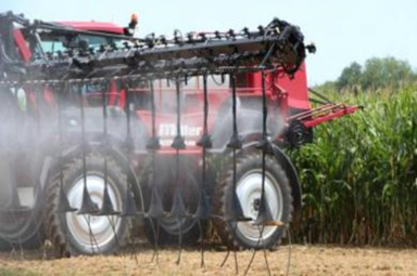
Step 4: Create a recommendation. Based on the findings, an application of fertilizer, herbicides, fungicides, or combination of the above might be economical. The imagery will calculate the number of acres that are healthy vs deficient and based on cost of treatment a plan can be created. Current technology allows for the turnaround from capturing the image, running soil scan, writing a prescription, and sending to a controller within as little as a few hours, if given accommodating weather and available manpower.
Andrew Tucker